Sunday, March 25, 2012

Migration, Movement, and Transportation, and More Rectified Maps

Migration, movement, and transportation in Kigali is very interesting. Let's start with migration. The major migration today is not within Africa or from different countries. It is the rural to urban migration that is changing not just Kigali, but also Africa. Like in the previous posts, Kigali's population has seen tremendous growth within the last couple of decades. Since independence, the population has increased almost 100 fold. That is incredible. Most of it is not from they influx of East African laborers or international ex-patriots, even though there are many in Kigali, but most of the explosion comes from the rural areas of Rwanda pouring into the Kigali, the capital and largest city. As the government pours more and more money into building Kigali, the population continues to grow. Thus, migration in Kigali has affected the landscape tremendously. The city has grown outwards, and even out of the valley. The roads are much nicer in the interior, but as people move to Kigali, and finding less and less opportunities, slums and poor communities develop and grow. Just looking at the overview of the city, on can see the compact conditions they live in today. In addition, as people continue to increase their wealth, Kigali's landscape is also moving upwards, as in skyscrapers and large financial, commercial, and political buildings grow in height. The Kigali Tower is a great example of the financial sector really flourishing.

As for movement, the way people get into the Kigali is either through bus or through air. There is actually no railways in Rwanda at all. Railways are often times developments of colonial powers, but since Kigali is far away from any water system, railways were never really developed. In addition, the colonial powers before the Belgians did not do too much with Rwanda, and instead, really left it alone. Nevertheless, since air and bus (mainly air) are the ways to get to Kigali, Rwanda's airport is actually quite nice. Much nicer than the airport I experienced in Dakar. Kigali welcomes foreigners with open arms, and the first thing they see is the airport. To them, the airport signifies quite a lot--a new frontier and a new future. The bus system in and out of the city are actually quite underdeveloped. While researching, I only found one major charter bus system, and they generally went to Kampala. So really, the mode of transportation in and out of the city is through air.

Finally, transportation in Kigali is split among motor taxis, minibuses called Matatus, and taxis. Motorcycle taxis are by far the easiest way to get around. They are the most common and they operate just like taxis, but instead are motorcycles. Also one of the most popular modes of transportation is the matatus. They are relatively new, and are kept in good condition. They are the bus system in Kigali and they operate quite nicely. Those who do not use motorcycle taxis usually opt for the matatus. They have a standardized price, depending on where you are going. Unlike taxis, you do not negotiate. Finally, there are taxis. The taxi system is pretty informal, and it really is just bargaining. However, there are also metered taxis in Kigali, and you usually have to call them and have them sent to where you are. That, to me, is quite interesting because in Dakar, metered taxis are nonexistent. Due to the modes of transportation, roads are often used. Roads in Kigali are nice in the city center, so by the Financial and Political centers. That is not surprising. The road to the airport is also quite nice, which is also to be expected. The roads, as you move further from the center, and out towards where most people live, become dirt roads and they can be quite difficult to travel on. Since Kigali is so hilly, transportation experiences are really hilly.

You can see an overview of distance and latitude and longitude of the Bus Station, Airport, Financial Center, and the Political Center. Like I said, there are not railways so there is no rail station involved.

Bus Station, Airport, Financial and Political Centers

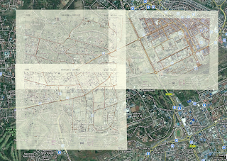
In addition, this week we rectified three more maps. Here are screenshots from my rectified Nairobi maps. My maps are generally quite easy to rectify and I have not encountered any problems.

The maps I have rectified so far. Nine out of the eleven that I have been assigned.
The three maps that were rectified this week.
One of the maps, separately.

One of the maps, separately.
 
One of the maps, separately.

Sunday, March 18, 2012

More Map of Nairobi Rectified and Kigali vs. Nairobi

This week I rectified three more maps of Nairobi. I like the maps that I was assigned because of how well they fit together. Individually they all look great, but together as a whole, they really paint the bigger picture and it looks phenomenal. I'm only about halfway done with all the rectified maps, but still, they look beautiful. Take a look!

This weeks three additional maps together. They are of the Thompson, Kilimani, Upper Hill, and Hurlingham Estates.
This is of the Hurlingham Estates with a little of the Kilimani and Upper Hill Estates.
This is mainly of the Thompson and Kilimani Estates.
This is mainly of the Kilimani Estates, with a little of the Upper Hill Estates 
All six of my rectified maps so far overlaid.

Next, we were asked to compare two rectified cities with your own. I was only given one city besides Kigali, so I am going to compare Nairobi with Kigali spatially. Now, the overall pictures of Kigali and Nairobi are pretty different.
Kigali
Nairobi at the same scale.
Now comparatively, we can already see a lot. Discounting color, since satellite pictures are hardly accurate when it comes to color, we can see that Nairobi is far larger than Kigali. The city spans almost the entire screenshot versus Kigali which takes up a small proportion. Interestingly enough, the land allotted to Kigali is just a bit bigger than the land allotted to Nairobi. That shows that Kigali has hardly expanded and has a long way to go to reach its limits. There can obviously be a multitude of factors which constricts Kigali from expanding. The biggest one is its terrain, since Kigali is in a valley between a few mountains. That makes building more difficult. Nairobi, however, is relatively flat. Now given that information, let's consider the population. Kigali is almost at a million inhabitants. Nairobi on the other hand, has roughly three million. Nairobi is three times the size in population! That is absolutely incredible. Yet the population density of Kigali seems way higher than Nairobi. Let's examine a closer picture.
Figure 1: Roadmap of a neighborhood in Kigali.
Figure 2: Satellite image of the exact same picture as Figure 1. 
Figure 3: A terrain view of a neighborhood in Kigali. It is NOT the same neighborhood as Figure 1 and 2.
Figure 4: Roadmap of a neighborhood in Nairobi. It is the exact same scale as Figure 1 and 2.
Figure 5: Satellite view of the exact same picture as Figure 4. 
Figure 6: A terrain view of a neighborhood in Nairobi. It is NOT the same neighborhood as Figure 4 and 5. It is the exact same scale as Figure 3.
So looking at Figure 2 and 5, we have a satellite image at exactly the same scale of two neighborhoods--one is Kigali and another in Nairobi. My first instinct is to say that Nairobi seems to be much more spread out in regions, with trees in yards. But it also has some really densely packed neighborhoods. It seems that there is a stark contrast in the wealthy and the poor in Nairobi. Though I cannot tell if it is gated, it almost looks like one part is a gated community while the other is not. You can tell immediately by just how green the area is. Looking at Kigali however, we immediately notice how densely packed everything is. Even some of the least densely packed areas of Kigali are more densely backed than the most densely packed areas in Nairobi. This all despite the fact Kigali has a population a third of Nairobi, though the geography forces them to live quite densely. Additionally, it looks like Nairobi has a lot more green space. Not necessarily greenery, but spaces that are simply meant for parks or fields. Kigali has very little of those spaces, oddly enough, given the perfect weather and soil there.

The next two figures I compared were Figure 1 and Figure 4. These are the two roadmap images of the same neighborhoods of Figure 2 and 5. I was interested in the roadmaps because I wanted to see how the streets were organized. It says a lot about a city by whether the streets are small, narrow and short, or if they are large and broad. It says a lot whether they're gridded or if they're all over the place. Looking at Kigali, we see that the streets aren't necessarily gridded, but they are organized in a very orderly fashion. However, the streets are almost aways curving. Very few of them are actually straight. The streets are generally quite long, but the space between streets are quite narrow. To contrast Kigali, Nairobi has very square streets. Similarly though, I would not say it is necessarily gridded, but there does seem to be some order to it. But the most important point to notice is that the streets do not curve as much. Streets are shorter and spaces between straights are larger than Kigali. I was curious as to why that was, so that's why I wanted to examine Figure 3 and 6.

Figure 3 and 6 are terrain maps of two neighborhoods in Nairobi and Kigali, both at the same scale. Now this map sheds so much light on to why Kigali and Nairobi streets are organized the way they are. If you look at Kigali's streets, the streets follow the terrain of the mountains and hills. Evidently, it is much easier to pave a road that is tangent to the contour line rather than perpendicular. That is why the streets seem to wrap around the terrain. That is also why they are longer but have less space in between them. Nairobi is relatively flat. It's not entirely flat, but for the most part they have freedom to pave streets whichever way they want. That explains why it looks much more gridded than Kigali does. Streets can be short, or long, curved or straight. And clearly, Nairobi has designed streets that vary in all shapes and sizes.

Sunday, March 4, 2012

Kigali Map, Article, Nairobi Maps, and Final Paper Ideas

Finding a map of Kigali was rather difficult. Kigali is such a young country that maps seem difficult to come by. It truly would be fascinating to find out what Kigali looked like even 50 years ago, since their population was around 6,000 people. For a very long time, they were considered one of the smallest capitals of an independent country in the entire world. However, I was not able to find an old map of Kigali. The map I did find was created by the US Defense Mapping Agency in 1994. That is an interesting time since that was right around the end of the Genocide. However, from literature that I've read, the infrastructure was not really damaged during those dark times, so really, it would not have been that different.

Interestingly enough, the map was created for military and humanitarian use only. It was classified, but declassified in 1994. The map is horrendously inaccurate spatially. When I was rectifying it, I added 20 control points because the map was made so oddly. The map now looks really warped, even though it is way more accurate now than before.

Rectified Map
That said, the map is still interesting to look at. Though it was made only 18 years ago, a lot has changed since. Buildings such as mosques or churches, stadiums, and most ministry buildings have stayed in the same position. That makes sense since those are the first thing we think as permanent fixtures in a city.

Stadium and Mosque are visible
Thinking about the purpose of the map, it was originally created for military and humanitarian uses, after the Genocide. So you can see here that the major roads are all highlighted, and also that the city center, where the financial district is, where the government center is, are the most detailed. You can see that in the first image posted. That's for obvious reason, but what surprises me is the detail of the neighborhoods. Many many streets are on the map, and even streets that today are dirt roads, or minor roads, are still on the map from 1994. I postulate that for military and humanitarian reasons, it's important to have the minor roads for accessibility and safety reasons.

The biggest changes from 1994 to today is the growth of the city. The city has grown tremendously, and even in the past 18 years, the population has exploded. So roads have gotten even more extensive where the map shows there are not that many.

The city roads have gotten much more extensive and larger neighborhoods have appeared where there used to be nothing.
Moving on to the article, newspaper articles from the past are not difficult to find, if you want newspapers produced by the west. Unfortunately, the Rwandan newspapers reported in French for a very long time, so many local newspapers are unintelligible to me. However, looking at the Western Newspaper, the longest one I found, and the oldest one I found is from the Milwaukee Journal in 1973.


Unfortunately, the article's audience are Americans that probably know very little about Rwanda. So the article lays out Rwanda's military coup, that was actually bloodless. But it paints a bleak picture about the future for Rwanda. It discusses the Tutsi-Hutu tensions, and the few rebellions that they have had. They highlight that the minority Tutsi rule over the majority Hutu. For the most part, the article is brief and informative for those who know nothing about the situation in Rwanda. It is also a minor minor section in the entire newspaper.

In general, the news articles in the past have highlighted the violence and tensions in Rwanda. While searching, I noticed articles up until 1994 have really emphasized the ethnic tension. Even articles back in the 60s and 70s mainly talk about the ethnic problems. However, after the genocide, from 1996 and on really, the articles talk about reconstruction. Then again, in the mid 2000s to today, many articles talk about Rwanda's improvement and future goals. There is a definitely progression in the articles. Both of these are expressed in Western newspapers and African newspapers as well.

Next, I have rectified three Nairobi Maps. It's surprisingly difficult to find the first map, but once you get it, the rest are not that bad.

Nairobi with three rectified maps.
Next is the discussion of the final paper idea. I remember in class, a classmate brought up a really interesting idea about the Germans and the Holocaust vs. the Rwandans and the Genocide. That is an idea I would be very interested in looking at, especially how the Rwandan government censors the rhetoric on genocide. Many believe that the Rwandan government is controlling the citizens and that would be an interesting idea to look at. Another idea would be to look at the population explosion over the past century. A country that goes from 6,000 to a little under one million is phenomenal. One could look at how the city has changed, and how it has adapted to accommodate the explosion. Lastly, another idea is looking at the Rwandan goals for the next decade. Rwanda has worked really hard on developing its economy, so looking at how Kigali has become the economic center of the country could be interesting. Of course one can also look at how the genocide impacted the city, but I feel that may be an overdone topic. But we shall see!