Migration, movement, and transportation in Kigali is very interesting. Let's start with migration. The major migration today is not within Africa or from different countries. It is the rural to urban migration that is changing not just Kigali, but also Africa. Like in the previous posts, Kigali's population has seen tremendous growth within the last couple of decades. Since independence, the population has increased almost 100 fold. That is incredible. Most of it is not from they influx of East African laborers or international ex-patriots, even though there are many in Kigali, but most of the explosion comes from the rural areas of Rwanda pouring into the Kigali, the capital and largest city. As the government pours more and more money into building Kigali, the population continues to grow. Thus, migration in Kigali has affected the landscape tremendously. The city has grown outwards, and even out of the valley. The roads are much nicer in the interior, but as people move to Kigali, and finding less and less opportunities, slums and poor communities develop and grow. Just looking at the overview of the city, on can see the compact conditions they live in today. In addition, as people continue to increase their wealth, Kigali's landscape is also moving upwards, as in skyscrapers and large financial, commercial, and political buildings grow in height. The Kigali Tower is a great example of the financial sector really flourishing.
As for movement, the way people get into the Kigali is either through bus or through air. There is actually no railways in Rwanda at all. Railways are often times developments of colonial powers, but since Kigali is far away from any water system, railways were never really developed. In addition, the colonial powers before the Belgians did not do too much with Rwanda, and instead, really left it alone. Nevertheless, since air and bus (mainly air) are the ways to get to Kigali, Rwanda's airport is actually quite nice. Much nicer than the airport I experienced in Dakar. Kigali welcomes foreigners with open arms, and the first thing they see is the airport. To them, the airport signifies quite a lot--a new frontier and a new future. The bus system in and out of the city are actually quite underdeveloped. While researching, I only found one major charter bus system, and they generally went to Kampala. So really, the mode of transportation in and out of the city is through air.
Finally, transportation in Kigali is split among motor taxis, minibuses called Matatus, and taxis. Motorcycle taxis are by far the easiest way to get around. They are the most common and they operate just like taxis, but instead are motorcycles. Also one of the most popular modes of transportation is the matatus. They are relatively new, and are kept in good condition. They are the bus system in Kigali and they operate quite nicely. Those who do not use motorcycle taxis usually opt for the matatus. They have a standardized price, depending on where you are going. Unlike taxis, you do not negotiate. Finally, there are taxis. The taxi system is pretty informal, and it really is just bargaining. However, there are also metered taxis in Kigali, and you usually have to call them and have them sent to where you are. That, to me, is quite interesting because in Dakar, metered taxis are nonexistent. Due to the modes of transportation, roads are often used. Roads in Kigali are nice in the city center, so by the Financial and Political centers. That is not surprising. The road to the airport is also quite nice, which is also to be expected. The roads, as you move further from the center, and out towards where most people live, become dirt roads and they can be quite difficult to travel on. Since Kigali is so hilly, transportation experiences are really hilly.
You can see an overview of distance and latitude and longitude of the Bus Station, Airport, Financial Center, and the Political Center. Like I said, there are not railways so there is no rail station involved.
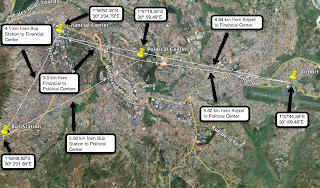 |
| Bus Station, Airport, Financial and Political Centers |
In addition, this week we rectified three more maps. Here are screenshots from my rectified Nairobi maps. My maps are generally quite easy to rectify and I have not encountered any problems.
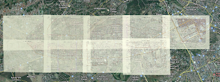 |
| The maps I have rectified so far. Nine out of the eleven that I have been assigned. |
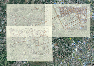 |
| The three maps that were rectified this week. |
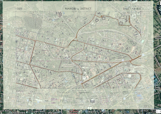 |
| One of the maps, separately. |
 |
| One of the maps, separately. |
|
 |
| One of the maps, separately. |
|


No comments:
Post a Comment